Home > North America > United States of America > Iowa > Cedar Rapids
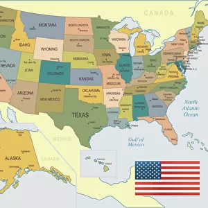
Cedar Rapids Iowa US City Street Map

![]()
Wall Art and Photo Gifts from Fine Art Storehouse
Cedar Rapids Iowa US City Street Map
Vector Illustration of a City Street Map of Cedar Rapids, Iowa, USA. Scale 1:60, 000.
All source data is in the public domain.
U.S. Geological Survey, US Topo
Used Layers:
USGS The National Map: National Hydrography Dataset (NHD)
USGS The National Map: National Transportation Dataset (NTD)
Unleash your creativity and transform your space into a visual masterpiece!
Frank Ramspott
Media ID 15192912
© Frank Ramspott, all rights reserved
Aerial View City Map Computer Graphic Directly Above Downtown District Gray Iowa Road Map Text Digitally Generated Image Green Color White Color
FEATURES IN THESE COLLECTIONS
> Aerial Photography
> Related Images
> Animals
> Insects
> Hemiptera
> Green Scale
> Arts
> Contemporary art
> Digital artwork
> Street art
> Arts
> Landscape paintings
> Waterfall and river artworks
> River artworks
> Arts
> Portraits
> Pop art gallery
> Street art portraits
> Arts
> Street art graffiti
> Digital art
> Digital paintings
> Arts
> Street art graffiti
> Digital art
> Vector illustrations
> Fine Art Storehouse
> Map
> Street Maps
> Fine Art Storehouse
> Map
> USA Maps
> Maps and Charts
> Geological Map
> Maps and Charts
> Related Images
> North America
> United States of America
> Iowa
> Cedar Rapids
EDITORS COMMENTS
This print showcases a meticulously detailed vector illustration of Cedar Rapids, Iowa's city street map. With a scale of 1:60,000, every intricate detail is brought to life in this stunning artwork. The artist, Frank Ramspott, has utilized various layers from the public domain source data including USGS The National Map: National Hydrography Dataset (NHD) and USGS The National Map: National Transportation Dataset (NTD). The image captures the essence of Cedar Rapids' downtown district with its bustling streets and vibrant energy. A beautiful lake and river add to the charm of this Midwestern cityscape. From roads winding through neighborhoods to major thoroughfares connecting different parts of town, every street is carefully depicted on this map. The design itself is digitally generated with no people present in the scene. The color palette features shades of gray, blue, white, and green which beautifully complement each other. This aerial view directly above Cedar Rapids allows viewers to appreciate the physical geography and layout of the city. Whether you are a cartography enthusiast or simply have an appreciation for fine art prints that showcase urban landscapes, this visually striking piece will surely captivate your attention. Perfect for home or office decor, it adds a touch of sophistication while celebrating the unique charm and character of Cedar Rapids, Iowa.
MADE IN THE USA
Safe Shipping with 30 Day Money Back Guarantee
FREE PERSONALISATION*
We are proud to offer a range of customisation features including Personalised Captions, Color Filters and Picture Zoom Tools
SECURE PAYMENTS
We happily accept a wide range of payment options so you can pay for the things you need in the way that is most convenient for you
* Options may vary by product and licensing agreement. Zoomed Pictures can be adjusted in the Cart.