Home > Animals > Mammals > Muridae > Steppe Mouse
Steppe-desert border, satellite image

![]()
Wall Art and Photo Gifts from Science Photo Library
Steppe-desert border, satellite image
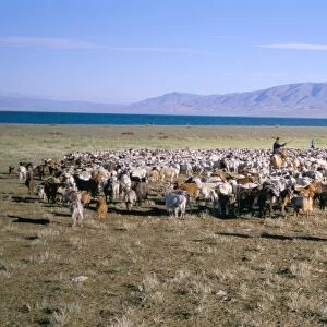
Steppe-desert border, satellite image. North is at top. Arid areas of desert rock are brown, while grassy steppe areas are green. A small area of desert sands (yellow) is seen at far centre right. Water in lakes (top centre) is dark blue. This area, called the Edrengiyn Nuruu, forms a transition zone between the Mongolian steppes to the north and the arid deserts of northern China to the south. The area shown in this image is around 170 kilometres wide. The image data includes infrared wavelengths, and was obtained on 13 August 1999, by the Landsat 7 satellite
Science Photo Library features Science and Medical images including photos and illustrations
Media ID 1705469
© NASA/SCIENCE PHOTO LIBRARY
1900s 1990s 1999 August China Chinese Desert Earth Observation Earth Science From Space Geological Grass Land Landsat 7 Mongolia Mongolian Physical Geography Rocky Sandy Satellite Satellite Image Steppe Vegetation
FEATURES IN THESE COLLECTIONS
> Animals
> Mammals
> Cricetidae
> Northern Grass Mouse
> Animals
> Mammals
> Cricetidae
> Northern Rock Mouse
> Animals
> Mammals
> Muridae
> Desert Mouse
> Animals
> Mammals
> Muridae
> Steppe Mouse
> Animals
> Mammals
> Muridae
> Water Mouse
> Asia
> China
> Lakes
> Related Images
> Asia
> Mongolia
> Lakes
> Related Images
> Asia
> Mongolia
> Related Images
> Asia
> Related Images
> Europe
> France
> Canton
> Landes
> Science Photo Library
> Aerial and Satellite
EDITORS COMMENTS
This satellite image captures the stunning beauty of the Steppe-desert border, showcasing a remarkable transition zone between the Mongolian steppes and the arid deserts of northern China. The print reveals a vast expanse of land, stretching approximately 170 kilometers wide, with its north direction at the top. The contrasting colors in this image are truly mesmerizing. The arid desert areas, composed of rugged rocks, appear in various shades of brown while the grassy steppe regions shine vibrantly in green hues. A small but striking patch of yellow desert sands can be seen towards the far center right. Adding to this breathtaking landscape are lakes that shimmer dark blue at the top center. These water bodies provide a stark contrast against their dry surroundings and add an element of tranquility to this otherwise harsh environment. Taken by Landsat 7 satellite on August 13th, 1999, this photograph utilizes infrared wavelengths to capture intricate details and showcase both geological formations and vegetation patterns. It offers valuable insights into Earth's physical geography and serves as a testament to our ever-advancing capabilities in earth observation from space. This extraordinary snapshot invites us to appreciate nature's wonders while highlighting the delicate balance between different ecosystems within our planet's diverse tapestry.
MADE IN THE USA
Safe Shipping with 30 Day Money Back Guarantee
FREE PERSONALISATION*
We are proud to offer a range of customisation features including Personalised Captions, Color Filters and Picture Zoom Tools
SECURE PAYMENTS
We happily accept a wide range of payment options so you can pay for the things you need in the way that is most convenient for you
* Options may vary by product and licensing agreement. Zoomed Pictures can be adjusted in the Cart.