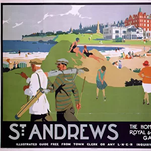
Home > Europe > United Kingdom > Scotland > Fife > St Andrews
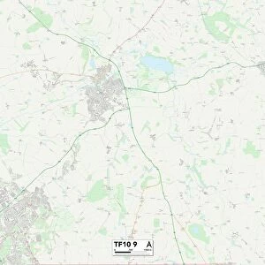
Telford and Wrekin TF10 9 Map

![]()
Wall Art and Photo Gifts from Map Marketing
Telford and Wrekin TF10 9 Map
Postcode Sector Map of Telford and Wrekin TF10 9
Media ID 19979432
Barnfield Close Barrack Lane Church Lane Church Meadow Church Road Dark Lane Grove Gardens Heath Road Highfield Hillside King Street Kings Street Limekiln Lane Moreton Nursery Lane Old Farm Lane Post Office Lane Primrose Drive Richmond Close St Andrews Way St Michaels Close Stockton Sylvan Close Telford And Wrekin The Close The Crescent The Folly The Spinney Walnut Tree Lane Wellington Road Woodcote Yew Tree Drive Brockton Chadwell Lilleshall Lynn Pinewoods
FEATURES IN THESE COLLECTIONS
> Animals
> Mammals
> Muridae
> Heath Mouse
> Europe
> United Kingdom
> Scotland
> Fife
> St Andrews
> Map Marketing
> Postcode Sector Maps
> TF - Telford
MADE IN THE USA
Safe Shipping with 30 Day Money Back Guarantee
FREE PERSONALISATION*
We are proud to offer a range of customisation features including Personalised Captions, Color Filters and Picture Zoom Tools
SECURE PAYMENTS
We happily accept a wide range of payment options so you can pay for the things you need in the way that is most convenient for you
* Options may vary by product and licensing agreement. Zoomed Pictures can be adjusted in the Cart.