Home > Animals > Birds > Passerines > White Eyes > Mountain White Eye
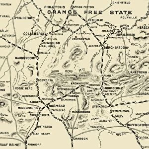
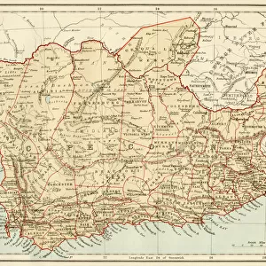
Bird s-Eye View of the Country Covered by General Bullers Operations for the Relief

![]()
Wall Art and Photo Gifts from Heritage Images
Bird s-Eye View of the Country Covered by General Bullers Operations for the Relief
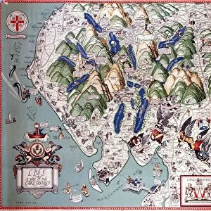
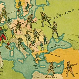
Bird s-Eye View of the Country Covered by General Bullers Operations for the Relief of Ladysmith, 1900. When the Second Boer War broke out on 11 October 1899, the Boers laid siege to Ladysmith, Kimberley and Mafeking. Redvers Buller commanded operations to lift the siege for the British. From " South Africa and the Transvaal War, Vol. III", by Louis Creswicke. [T. C. & E. C. Jack, Edinburgh, 1900]
Heritage Images features heritage image collections
Media ID 19780737
© The Print Collector/Heritage Images
1899 1902 2nd Boer War Bamp W Boer Boer Wars Boers Buller Colonel Redvers Buller Creswicke Diagram General Buller James Russell And Sons Ladysmith Louis Louis Creswicke Plan Province Of Kwazulu Natal Redvers Redvers Buller Redvers Henry Redvers Henry Buller Route Russell And Sons Second Boer War Second Transvaal War Siege Siege Of Ladysmith Sir Redvers Sir Redvers Buller Sir Redvers Henry Buller South Africa South Africa And The Transvaal War South African Strategic Strategy
FEATURES IN THESE COLLECTIONS
> Africa
> Related Images
> Africa
> South Africa
> Maps
> Africa
> South Africa
> Related Images
> Animals
> Birds
> Passerines
> White Eyes
> Mountain White Eye
> Arts
> Literature
> Europe
> United Kingdom
> Scotland
> Edinburgh
> Edinburgh
> Europe
> United Kingdom
> Scotland
> Lothian
> Edinburgh
> Maps and Charts
> British Empire Maps
> Maps and Charts
> Related Images
EDITORS COMMENTS
This print titled "Bird's-Eye View of the Country Covered by General Buller's Operations for the Relief of Ladysmith, 1900" offers a glimpse into a significant moment in history. Taken during the Second Boer War, it showcases the strategic planning and military operations led by General Redvers Buller to lift the siege on Ladysmith. The image depicts a vast landscape with majestic mountains dominating the scene. The intricate details captured in this bird's-eye view map highlight various geographical features, routes, and key locations crucial to British forces. It serves as both a historical document and an artistic representation of Victorian-era military strategy. Louis Creswicke's book "South Africa and the Transvaal War" provides further context to understand this pivotal event in South African history. The print itself is a testament to Britain's determination to maintain its empire during challenging times. As we observe this photograph today, it reminds us of the bravery and sacrifices made by soldiers like Sir Redvers Henry Buller who played vital roles in conflicts that shaped nations. This print is not just an artifact; it represents resilience, courage, and human endeavor against adversity.
MADE IN THE USA
Safe Shipping with 30 Day Money Back Guarantee
FREE PERSONALISATION*
We are proud to offer a range of customisation features including Personalised Captions, Color Filters and Picture Zoom Tools
SECURE PAYMENTS
We happily accept a wide range of payment options so you can pay for the things you need in the way that is most convenient for you
* Options may vary by product and licensing agreement. Zoomed Pictures can be adjusted in the Cart.