Home > Arts > Street art graffiti > Digital art > Vector illustrations
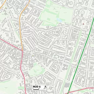
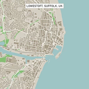
Midland Texas US City Street Map

![]()
Wall Art and Photo Gifts from Fine Art Storehouse
Midland Texas US City Street Map
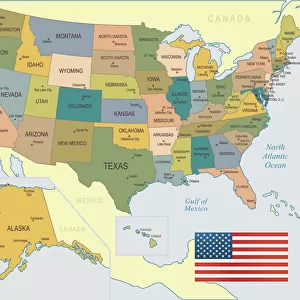
Vector Illustration of a City Street Map of Midland, Texas, USA. Scale 1:60, 000.
All source data is in the public domain.
U.S. Geological Survey, US Topo
Used Layers:
USGS The National Map: National Hydrography Dataset (NHD)
USGS The National Map: National Transportation Dataset (NTD)
Unleash your creativity and transform your space into a visual masterpiece!
Frank Ramspott
Media ID 15192932
© Frank Ramspott, all rights reserved
Aerial View City Map Computer Graphic Directly Above Downtown District Gray Road Map Texas Text Digitally Generated Image Green Color Midland White Color
FEATURES IN THESE COLLECTIONS
> Aerial Photography
> Related Images
> Animals
> Insects
> Hemiptera
> Green Scale
> Arts
> Contemporary art
> Digital artwork
> Street art
> Arts
> Landscape paintings
> Waterfall and river artworks
> River artworks
> Arts
> Portraits
> Pop art gallery
> Street art portraits
> Arts
> Street art graffiti
> Digital art
> Digital paintings
> Arts
> Street art graffiti
> Digital art
> Vector illustrations
> Fine Art Storehouse
> Map
> Street Maps
> Fine Art Storehouse
> Map
> USA Maps
> Maps and Charts
> Geological Map
> Maps and Charts
> Related Images
> North America
> United States of America
> Lakes
> Related Images
EDITORS COMMENTS
This print showcases a meticulously detailed city street map of Midland, Texas, USA. With a scale of 1:60,000, every intricate detail is brought to life in this vector illustration. The artist has skillfully utilized various layers from the USGS The National Map to create this visually stunning piece. The map encompasses the entire downtown district of Midland and extends beyond its borders to include nearby lakes and rivers. Every street and road is intricately depicted, providing an accurate representation of the city's layout. This digital image seamlessly combines cartography with modern design techniques. The aerial view perspective allows us to appreciate the physical geography of Midland from directly above. The color palette chosen by Frank Ramspott adds depth and vibrancy to the artwork - shades of gray, blue, white, and green are harmoniously blended together. This print offers more than just a visual representation; it serves as a testament to the rich history and development of Midland as well. All source data used in creating this masterpiece is in the public domain courtesy of U. S Geological Survey (USGS) - specifically their National Hydrography Dataset (NHD) and National Transportation Dataset (NTD). Whether you're a resident or visitor fascinated by maps or simply seeking unique wall art that celebrates urban landscapes, this digitally generated image will undoubtedly captivate your attention for years to come.
MADE IN THE USA
Safe Shipping with 30 Day Money Back Guarantee
FREE PERSONALISATION*
We are proud to offer a range of customisation features including Personalised Captions, Color Filters and Picture Zoom Tools
SECURE PAYMENTS
We happily accept a wide range of payment options so you can pay for the things you need in the way that is most convenient for you
* Options may vary by product and licensing agreement. Zoomed Pictures can be adjusted in the Cart.