Home > Europe > United Kingdom > England > Cambridgeshire > Nene
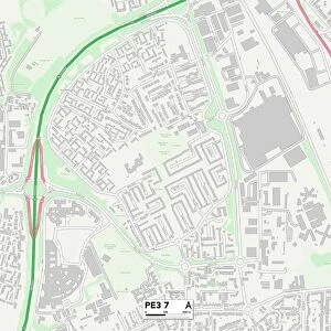
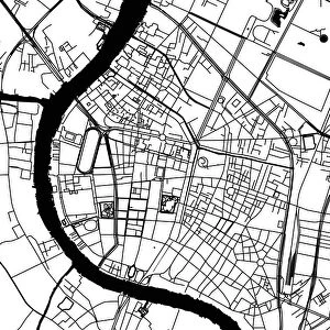
Peterborough Cambridgeshire UK City Street Map

![]()
Wall Art and Photo Gifts from Fine Art Storehouse
Peterborough Cambridgeshire UK City Street Map
Vector Illustration of a City Street Map of Peterborough, Cambridgeshire, UK. Included files are EPS (v10) and Hi-Res JPG.
Data courtesy from Ordnance Survey: VectorMap District
https:/ordnancesurvey.co.uk/business-and-government/products/vectormap-district.html
OS OpenData is free to use under the Open Government Licence (OGL).
Contains OS data eCrown copyright and database right 2017.
http:/nationalarchives.gov.uk/doc/open-government-licence/version/3/
Unleash your creativity and transform your space into a visual masterpiece!
Frank Ramspott
Media ID 15055257
© Frank Ramspott, all rights reserved
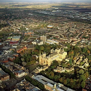
Aerial View Cambridgeshire Computer Graphic Directly Above Gray Green Road Map Street Map Text Digitally Generated Image Peterborough River Nene
FEATURES IN THESE COLLECTIONS
> Aerial Photography
> Related Images
> Animals
> Birds
> Waterfowl
> Geese
> Nene
> Arts
> Contemporary art
> Digital artwork
> Street art
> Arts
> Landscape paintings
> Waterfall and river artworks
> River artworks
> Arts
> Portraits
> Pop art gallery
> Street art portraits
> Arts
> Street art graffiti
> Digital art
> Digital paintings
> Arts
> Street art graffiti
> Digital art
> Vector illustrations
> Europe
> United Kingdom
> England
> Cambridgeshire
> The Green
> Europe
> United Kingdom
> England
> Cambridgeshire
> Nene
> Europe
> United Kingdom
> England
> Cambridgeshire
> Peterborough
> Fine Art Storehouse
> Map
> Street Maps
EDITORS COMMENTS
This print showcases a meticulously detailed city street map of Peterborough, Cambridgeshire in the United Kingdom. Created as a vector illustration, this artwork beautifully captures the essence of the city's layout and architecture. The inclusion of EPS (v10) and Hi-Res JPG files ensures that this print can be enjoyed in various formats. The data used to create this stunning piece is courtesy of Ordnance Survey: VectorMap District, a reliable source for accurate mapping information. It is worth noting that OS OpenData allows free usage under the Open Government Licence (OGL), highlighting its accessibility and commitment to open sharing. Featuring elements such as the River Nene, buildings, streets, roads, and more, this design offers an immersive experience into Peterborough's urban landscape. The digitally generated image presents an aerial view directly above the cityscape with text elegantly incorporated throughout. With a color palette consisting of gray, green, blue, and white hues, this print effortlessly blends artistry with functionality. Its visually appealing composition makes it suitable for both decorative purposes and practical navigation needs. Created by talented artist Frank Ramspott exclusively for Fine Art Storehouse -
MADE IN THE USA
Safe Shipping with 30 Day Money Back Guarantee
FREE PERSONALISATION*
We are proud to offer a range of customisation features including Personalised Captions, Color Filters and Picture Zoom Tools
SECURE PAYMENTS
We happily accept a wide range of payment options so you can pay for the things you need in the way that is most convenient for you
* Options may vary by product and licensing agreement. Zoomed Pictures can be adjusted in the Cart.