Home > Europe > France > Paris > Maps
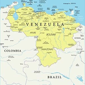
Map of Venezuela and British Guiana (engraving)
")
![]()
Wall Art and Photo Gifts from Fine Art Finder
Map of Venezuela and British Guiana (engraving)
1056863 Map of Venezuela and British Guiana (engraving) by English School, (19th century); Private Collection; (add.info.: Map of Venezuela and British Guiana. Illustration for The Graphic, 28 December 1895.); Look and Learn / Illustrated Papers Collection
Media ID 22222620
© Look and Learn / Illustrated Papers Collection / Bridgeman Images
British Guiana British Territory Demerara Treaty Of Paris Venezuela Berbice Essequibo
FEATURES IN THESE COLLECTIONS
> Europe
> France
> Paris
> Maps
> Europe
> United Kingdom
> England
> Maps
> Europe
> United Kingdom
> England
> Posters
> Europe
> United Kingdom
> Maps
> Fine Art Finder
> Artists
> English School
> Fine Art Finder
> Temp Classification
> Maps and Charts
> Related Images
> South America
> Venezuela
> Maps
> South America
> Venezuela
> Related Images
EDITORS COMMENTS
This engraving, titled "Map of Venezuela and British Guiana" takes us back to the 19th century when cartography was a vital tool for exploration and territorial disputes. The print showcases the intricate details of the map, highlighting the boundaries between British Guiana (present-day Guyana) and Venezuela. As we delve into this historical artifact, we are transported to an era where colonial powers vied for control over vast territories. The map reveals not only the British possessions in South America but also Dutch holdings in what is now Suriname. It serves as a visual representation of political agreements such as the Treaty of Paris that shaped these regions. The inclusion of various landmarks like Yuruan, Venezuelan posts, and the Schomburgk boundary adds depth to our understanding of this complex geopolitical landscape. We can almost imagine explorers studying this very map before embarking on their expeditions or diplomats using it during negotiations. Beyond its geographical significance, this engraving offers insights into British culture at that time. It reminds us of Britain's imperial ambitions while showcasing European influence on global affairs. Moreover, it highlights how maps were not just tools but also works of art that captured people's imaginations. Preserved in a private collection, this remarkable print from Look and Learn / Illustrated Papers Collection allows us to appreciate both its historical value and artistic beauty. It invites us to reflect upon our ever-evolving world while honoring those who meticulously mapped it centuries ago.
MADE IN THE USA
Safe Shipping with 30 Day Money Back Guarantee
FREE PERSONALISATION*
We are proud to offer a range of customisation features including Personalised Captions, Color Filters and Picture Zoom Tools
SECURE PAYMENTS
We happily accept a wide range of payment options so you can pay for the things you need in the way that is most convenient for you
* Options may vary by product and licensing agreement. Zoomed Pictures can be adjusted in the Cart.