Home > Arts > Artists > O > Oceanic Oceanic
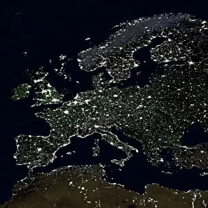
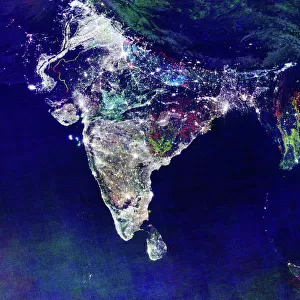
India at night, satellite image

![]()
Wall Art and Photo Gifts from Science Photo Library
India at night, satellite image
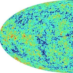
India at night, satellite view. This image is a composite showing the change in illumination over India from 1992-2003. Satellite data from 2003 is coloured red, 1998 is coloured green and 1992 is blue. The three data sets are composited to form the image. Nighttime lights on the map that are white are lights that were present throughout the entire period. Areas that are marked by red have only appeared in 2003. Areas coloured green and blue were only present in 1998 and 1992 respectively but are no longer visible. This image was created by the Defense Meteorological Satellite Program (DMSP), National Oceanic & Atmospheric Administration, USA.
*** THIS PICTURE MAY NOT BE USED TO STATE OR IMPLY NOa ENDORSEMENT OF ANY COMPANY OR PRODUCT ***
Science Photo Library features Science and Medical images including photos and illustrations
Media ID 1705155
© NOAA/SCIENCE PHOTO LIBRARY
1992 1998 2003 Cities City Composite Developing World Development Earth Observation Earth Science From Space India Indian Ocean Light Light Pollution Lights Pakistan Satellite Satellite Image Sciences Sri Lanka Third World Urban Sprawl Urbanisation Urbanization Night Lights Urban Growth
FEATURES IN THESE COLLECTIONS
> Arts
> Artists
> O
> Oceanic Oceanic
> Asia
> India
> Related Images
> Asia
> Pakistan
> Related Images
> Asia
> Related Images
> Asia
> Sri Lanka
> Related Images
> Maps and Charts
> India
> Maps and Charts
> Related Images
> Science Photo Library
> Aerial and Satellite
EDITORS COMMENTS
This print showcases the stunning transformation of India's nighttime illumination from 1992 to 2003. The composite image, created by the Defense Meteorological Satellite Program (DMSP) in collaboration with the National Oceanic & Atmospheric Administration (NOAA) of the USA, provides a unique perspective on urban growth and development in this vast Asian nation. Intriguingly, different colors represent distinct periods within this decade-long span. The vibrant red hue signifies areas that only emerged as illuminated regions in 2003, while green represents lights present solely in 1998. Blue indicates locations that were visible during 1992 but have since faded into darkness. The presence of white lights throughout all three timeframes suggests continuous urbanization and steady progress across India. However, it is impossible to ignore the stark contrast between these thriving metropolitan areas and those marked by disappearing or newly emerging lights. Beyond its aesthetic appeal, this satellite view prompts reflection on broader themes such as light pollution, urban sprawl, and socioeconomic disparities within developing countries like India. It serves as a powerful reminder of how human activity shapes our planet's landscape and offers valuable insights for researchers studying Earth observation and geography.
MADE IN THE USA
Safe Shipping with 30 Day Money Back Guarantee
FREE PERSONALISATION*
We are proud to offer a range of customisation features including Personalised Captions, Color Filters and Picture Zoom Tools
SECURE PAYMENTS
We happily accept a wide range of payment options so you can pay for the things you need in the way that is most convenient for you
* Options may vary by product and licensing agreement. Zoomed Pictures can be adjusted in the Cart.