Home > Arts > Artists > H > Jodocus Hondius
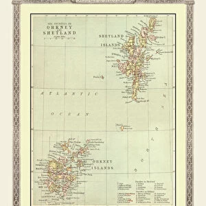
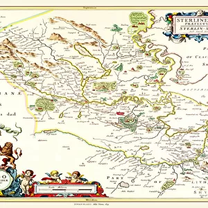
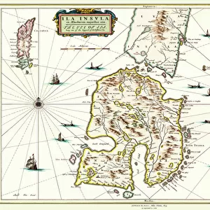
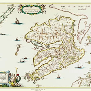
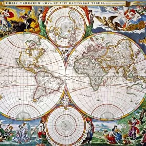
Old Map of the Isles of Shetland and Orkney 1654 from the Atlas Novus

![]()
Wall Art and Photo Gifts from MapSeeker
Old Map of the Isles of Shetland and Orkney 1654 from the Atlas Novus
This detailed and most attractive reproduction map of The Isles of Shetland and Orkney, has been carefully art worked from a scan of an antique original. The famous firm of Dutch cartographers and publishers was established in the late 16th century by Willem Janszoon Blaeu in Amsterdam. Blaeu was a maker of globes and scientific instruments and purchased some of his early map plates from Jodocus Hondius. From this small beginning was to emerge one of the largest and most prolific map publishing houses of the seventeenth century
Welcome to the Mapseeker Image library and enter an historic gateway to one of the largest on-line collections of Historic Maps, Nostalgic Views, Vista's and Panorama's from a World gone by.
Media ID 20348017
Blaeu Blaeu Family Blaue Map Historic Map Johan Blaeu Johan Blaeu Map Old Blaue Map Orkney Shetland Shetlands
FEATURES IN THESE COLLECTIONS
> Arts
> Artists
> B
> Willem Blaeu
> Arts
> Artists
> H
> Jodocus Hondius
> Arts
> Photorealistic artworks
> Detailed art pieces
> Masterful detailing in art
> Europe
> United Kingdom
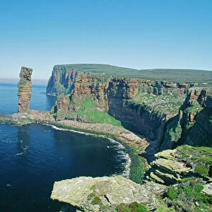
> Scotland
> Orkney
> Europe
> United Kingdom
> Scotland
> Shetland
> Maps and Charts
> Early Maps
> Maps and Charts
> Related Images
> Maps and Charts
> Willem Janszoon Blaeu
> MapSeeker
> Maps from the British Isles
> Scotland and Counties PORTFOLIO
EDITORS COMMENTS
This beautifully crafted reproduction of the "Old Map of the Isles of Shetland and Orkney 1654" takes us on a journey back in time. Carefully art worked from an antique original, this map captures the intricate details and allure of these historic Scottish islands. Originally created by Johan Blaeu, a renowned Dutch cartographer and publisher, this map is a testament to his expertise in mapmaking. Blaeu's firm, established in Amsterdam during the late 16th century, would go on to become one of the largest and most prolific map publishing houses of the seventeenth century. The Isles of Shetland and Orkney are depicted with remarkable precision on this historic piece. Every contour line, coastline, and settlement is meticulously illustrated, offering a glimpse into what life was like centuries ago. The rich history and cultural heritage associated with these islands come alive through this detailed representation. Whether you're an avid historian or simply fascinated by maps, this reproduction will transport you to another era. It serves as a reminder that our world has evolved over time while preserving its unique charm. Displaying it proudly in your home or office will not only be aesthetically pleasing but also spark conversations about the captivating stories hidden within these ancient lands.
MADE IN THE USA
Safe Shipping with 30 Day Money Back Guarantee
FREE PERSONALISATION*
We are proud to offer a range of customisation features including Personalised Captions, Color Filters and Picture Zoom Tools
SECURE PAYMENTS
We happily accept a wide range of payment options so you can pay for the things you need in the way that is most convenient for you
* Options may vary by product and licensing agreement. Zoomed Pictures can be adjusted in the Cart.