Home > Mary Evans Prints Online > New Images August 2021
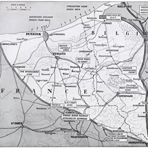
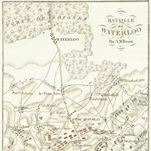
Map of Dunkirk area during the evacuation, WW2

![]()
Wall Art and Photo Gifts from Mary Evans Picture Library
Map of Dunkirk area during the evacuation, WW2
Map of the Dunkirk area in northern France during the evacuation, showing two flooded areas of low-lying meadow land which assisted in the Allied retreat. Date: 1940
Mary Evans Picture Library makes available wonderful images created for people to enjoy over the centuries
Media ID 23275268
© Illustrated London News Ltd/Mary Evans
Dunkirk Evacuated Evacuation Expeditionary Maps Nov19 Rescue Rescued Return Saved
FEATURES IN THESE COLLECTIONS
> Animals
> Mammals
> Muridae
> Fortior
> Europe
> Belgium
> Related Images
> Europe
> France
> Canton
> Landes
> Historic
> World War I and II
> World War II
> Mary Evans Prints Online
> New Images August 2021
EDITORS COMMENTS
This evocative map depicts the Dunkirk area in northern France during the momentous evacuation of Allied troops in May 1940. The retreat, also known as Operation Dynamo, took place against the backdrop of the advancing German forces during World War II. The map highlights two flooded areas of low-lying meadow land, which played a crucial role in the successful evacuation of the British Expeditionary Force (BEF) and other Allied soldiers. The flooded zones, marked by the dark blue patches in the map, were intentionally inundated by the British military to hinder the progress of the German forces and create a natural barrier. This tactic, combined with the heroic efforts of the Royal Navy and civilian vessels, enabled the evacuation of over 338,000 Allied soldiers from the beaches of Dunkirk. The map, dated 1940, illustrates the strategic importance of the flooded areas during the evacuation. The British troops and civilians were able to retreat to these areas, which were inaccessible to the German forces due to the water, and wait for rescue. The map also reveals the proximity of the evacuation site to the Belgian border, emphasizing the international nature of the operation. This map is a poignant reminder of the bravery and resourcefulness of those involved in the Dunkirk evacuation, which proved to be a turning point in the war, allowing the Allied forces to regroup and eventually emerge victorious. The map serves as a testament to the resilience and determination of the Allied forces during a critical moment in world history.
MADE IN THE USA
Safe Shipping with 30 Day Money Back Guarantee
FREE PERSONALISATION*
We are proud to offer a range of customisation features including Personalised Captions, Color Filters and Picture Zoom Tools
SECURE PAYMENTS
We happily accept a wide range of payment options so you can pay for the things you need in the way that is most convenient for you
* Options may vary by product and licensing agreement. Zoomed Pictures can be adjusted in the Cart.