Home > North America > United States of America > New York > New York > Maps
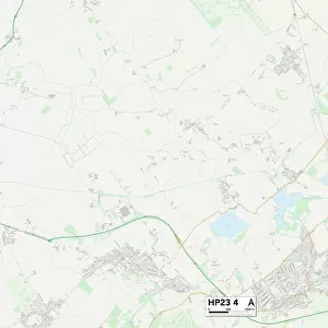
Wycombe HP12 3 Map

![]()
Wall Art and Photo Gifts from Map Marketing
Wycombe HP12 3 Map
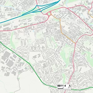
Postcode Sector Map of Wycombe HP12 3
Media ID 19972052
Acorn Gardens Albion Road Blenheim Road Bramley Close Burnham Close Bushey Close Carrington Road Chiltern Avenue Coronation Road Cross Road Eaton Avenue Grafton Street Grenfell Avenue Halifax Road Juniper Drive Laburnum Road Lancaster Road Lincoln Road Lindsay Avenue Link Road Maple Close Middle Way Mount Close Mulberry Close New Road Rutland Avenue Shackleton Road Stirling Road Thrush Close Turnpike Road Turnpike Way Vanguard Close Wellington Road Whitelands Road Wycombe York Way Knights Hill
FEATURES IN THESE COLLECTIONS
> Animals
> Birds
> Passerines
> Thrushes
> Related Images
> Europe
> United Kingdom
> England
> Rutland
> Related Images
> Europe
> United Kingdom
> Scotland
> Stirlingshire
> Stirling
> Map Marketing
> Postcode Sector Maps
> HP - Hemel Hempstead
> Maps and Charts
> Related Images
> North America
> United States of America
> New York
> New York
> Maps
> North America
> United States of America
> New York
> Related Images
MADE IN THE USA
Safe Shipping with 30 Day Money Back Guarantee
FREE PERSONALISATION*
We are proud to offer a range of customisation features including Personalised Captions, Color Filters and Picture Zoom Tools
SECURE PAYMENTS
We happily accept a wide range of payment options so you can pay for the things you need in the way that is most convenient for you
* Options may vary by product and licensing agreement. Zoomed Pictures can be adjusted in the Cart.