Home > Arts > Artists > T > John Tallis
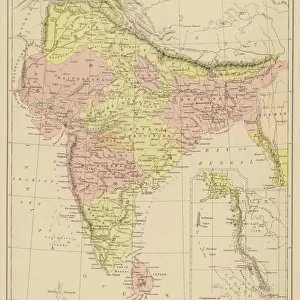
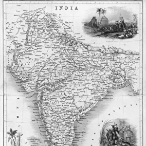
Overland Route to India 1851

![]()
Wall Art and Photo Gifts from MapSeeker
Overland Route to India 1851
A fine facimile artworked from an antique original map of the Overland Route to India, issued as part of the 1851 edition of John Tallis and Companys " The Illustrated Atlas and Modern History of the World"
Welcome to the Mapseeker Image library and enter an historic gateway to one of the largest on-line collections of Historic Maps, Nostalgic Views, Vista's and Panorama's from a World gone by.
Media ID 20347479
© Mapseeker Publishing Ltd
John Tallis John Tallis Map Tallis Tallis Map
FEATURES IN THESE COLLECTIONS
> Arts
> Artists
> T
> John Tallis
> Asia
> India
> Related Images
> Maps and Charts
> India
> Maps and Charts
> Related Images
> Maps and Charts
> World
> MapSeeker
> Maps of Asia and Middle East
> Maps of Countries in Asia PORTFOLIO
EDITORS COMMENTS
This print showcases a remarkable piece of cartographic history - the Overland Route to India map from 1851. A true work of art, this fine facsimile has been meticulously crafted from an antique original, preserving every intricate detail for posterity. Part of John Tallis and Company's renowned "The Illustrated Atlas and Modern History of the World" this map offers a fascinating glimpse into the past. With its ornate borders and elegant typography, it transports us back to a time when exploration and trade routes were at the forefront of global affairs. As we gaze upon this old Indian map, we are reminded of the vastness and diversity that India encompasses. From its northernmost reaches to its southern tip, every region is intricately depicted with precision and accuracy. The Overland Route itself takes center stage, tracing a complex network of roads connecting Europe to India through various countries along the way. John Tallis' expertise in cartography shines through in this masterpiece as he expertly captures not only geographical features but also cultural nuances within each territory represented on the map. It serves as both an educational resource for historians and geographers alike while also evoking a sense of wonderment at how our world has evolved over time. With this print adorning your walls, you invite viewers to embark on their own journey through history - exploring ancient trade routes, marveling at forgotten landscapes, and appreciating the craftsmanship that went into creating such an exquisite artifact.
MADE IN THE USA
Safe Shipping with 30 Day Money Back Guarantee
FREE PERSONALISATION*
We are proud to offer a range of customisation features including Personalised Captions, Color Filters and Picture Zoom Tools
SECURE PAYMENTS
We happily accept a wide range of payment options so you can pay for the things you need in the way that is most convenient for you
* Options may vary by product and licensing agreement. Zoomed Pictures can be adjusted in the Cart.