Home > Arts > Street art graffiti > Digital art > Vector illustrations
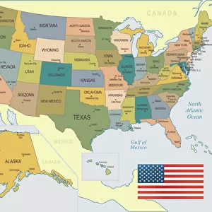
Concord California US City Street Map

![]()
Wall Art and Photo Gifts from Fine Art Storehouse
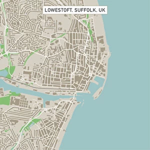
Concord California US City Street Map
Vector Illustration of a City Street Map of Concord, California, USA. Scale 1:60, 000.
All source data is in the public domain.
U.S. Geological Survey, US Topo
Used Layers:
USGS The National Map: National Hydrography Dataset (NHD)
USGS The National Map: National Transportation Dataset (NTD)
Unleash your creativity and transform your space into a visual masterpiece!
Frank Ramspott
Media ID 15055079
© Frank Ramspott, all rights reserved
Aerial View California City Map Computer Graphic Directly Above Downtown District Gray Road Map Text Concord Digitally Generated Image Green Color White Color
FEATURES IN THESE COLLECTIONS
> Aerial Photography
> Related Images
> Animals
> Insects
> Hemiptera
> Green Scale
> Animals
> Mammals
> Cricetidae
> California Mouse
> Arts
> Contemporary art
> Digital artwork
> Street art
> Arts
> Landscape paintings
> Waterfall and river artworks
> River artworks
> Arts
> Portraits
> Pop art gallery
> Street art portraits
> Arts
> Street art graffiti
> Digital art
> Digital paintings
> Arts
> Street art graffiti
> Digital art
> Vector illustrations
> Fine Art Storehouse
> Map
> Street Maps
> Fine Art Storehouse
> Map
> USA Maps
> Maps and Charts
> Geological Map
> Maps and Charts
> Related Images
EDITORS COMMENTS
This print showcases a meticulously detailed vector illustration of the city street map of Concord, California, USA. With a scale of 1:60,000, this artwork provides an intricate depiction of the city's downtown district, river, lake, and streets. The design is digitally generated with vibrant colors including shades of gray, green, blue and white. The source data used in creating this masterpiece is from the public domain and includes layers from USGS The National Map: National Hydrography Dataset (NHD) and USGS The National Map: National Transportation Dataset (NTD). These datasets ensure accuracy and precision in representing the geography and transportation network within Concord. With no people visible in the image due to its aerial view captured directly above the cityscape, this print focuses solely on showcasing the beauty and complexity of Concord's urban landscape. It highlights various elements such as roads, buildings, parks, and landmarks that make up this thriving city. Created by talented artist Frank Ramspott for Fine Art Storehouse's collection; it combines cartography expertise with computer graphics to produce a visually stunning representation. This unique piece serves as both an informative tool for navigation enthusiasts or locals seeking familiarity with their surroundings while also functioning as an aesthetically pleasing work of art suitable for any space.
MADE IN THE USA
Safe Shipping with 30 Day Money Back Guarantee
FREE PERSONALISATION*
We are proud to offer a range of customisation features including Personalised Captions, Color Filters and Picture Zoom Tools
SECURE PAYMENTS
We happily accept a wide range of payment options so you can pay for the things you need in the way that is most convenient for you
* Options may vary by product and licensing agreement. Zoomed Pictures can be adjusted in the Cart.