Home > Europe > United Kingdom > England > Avon
Leeds LS25 1 Map

![]()
Wall Art and Photo Gifts from Map Marketing
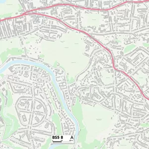
Leeds LS25 1 Map
Postcode Sector Map of Leeds LS25 1
Media ID 19973783
Alandale Road Avon Drive Brunswick Gardens Burnham Road Chapel Close Chapel Lane Church Gardens Church Lane Church Place Church Square Cyprus Road Derwent Avenue Glendale Avenue Grange Avenue Highfield Drive Kings Croft Kingsway Leeds Lindsay Road Lowther Avenue Lowther Drive Lowther Road Main Street Medway Avenue Mortimer Close Oak Avenue Oak Crescent Oak Drive Oak Grove Oak Place Oak Road Oakfield Close Paddock Close Pentland Drive Pinfold Lane Poplar Avenue Providence Place Queensway Rectory Close Richmond Way Ringway Rose Court Rydal Avenue Selby Road Springbank Springbank Crescent Springfield Place St Josephs Court St Marys Close Station Close Summerhill Road Templars Way Town End Wakefield Road Westbourne Avenue Westbourne Crescent Westbourne Drive Westbourne Gardens Westbourne Grove Westbourne Terrace Westway Windermere Drive Garforth
FEATURES IN THESE COLLECTIONS
> Asia
> Cyprus
> Related Images
> Europe
> United Kingdom
> England
> Avon
> Map Marketing
> Postcode Sector Maps
> LS - Leeds
> Maps and Charts
> Related Images
MADE IN THE USA
Safe Shipping with 30 Day Money Back Guarantee
FREE PERSONALISATION*
We are proud to offer a range of customisation features including Personalised Captions, Color Filters and Picture Zoom Tools
SECURE PAYMENTS
We happily accept a wide range of payment options so you can pay for the things you need in the way that is most convenient for you
* Options may vary by product and licensing agreement. Zoomed Pictures can be adjusted in the Cart.