Home > Stocktrek Images > Space
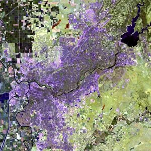
Satellite view of Amsterdam, Netherlands

![]()
Wall Art and Photo Gifts from Stocktrek
Satellite view of Amsterdam, Netherlands
July 24, 2012 - Satellite view of Amsterdam, Netherlands. Urbanized areas appear in shades of gray; vegetation is red; and water is blue. The concentric canals appear as blue semicircles spreading out from the historic city center
Stocktrek Images specializes in Astronomy, Dinosaurs, Medical, Military Forces, Ocean Life, & Sci-Fi
Media ID 13014141
© Stocktrek Images
Canal Capital Cities Cartography City Coast Coastline Earth Observation Europe Geography Green Land Meteorology Netherlands Overhead View Patchwork Landscape Physical Geography Satellite View Square Image Topography Urban Area Weather Polder View From Space
EDITORS COMMENTS
This print showcases a mesmerizing satellite view of the enchanting city of Amsterdam, Netherlands. Taken on July 24,2012, this square image captures the essence of the capital city in all its glory. The urbanized areas are depicted in varying shades of gray, while vibrant red hues represent lush vegetation and tranquil blue tones symbolize flowing water. The most striking feature is undoubtedly the concentric canals that gracefully spread out from the historic city center like delicate blue semicircles. This unique aerial perspective offers a remarkable insight into Amsterdam's distinctive patchwork landscape and highlights its intricate network of waterways. With no people visible in this photograph, it allows us to appreciate the sheer beauty and tranquility of this European gem from a celestial vantage point. The coastline stretches along one side, blending seamlessly with green spaces that dot the landscape. As we gaze upon this breathtaking view from space, we are reminded not only of Amsterdam's rich history but also its harmonious coexistence with nature. This image serves as a testament to our ability to create thriving urban areas while preserving our environment. Captured by Stocktrek Images through earth observation technology, this stunning piece combines elements of cartography and topography to present an overhead view that reveals both land formations and meteorological patterns. It is truly an awe-inspiring representation of Amsterdam's physical geography at its finest – a true masterpiece for any admirer or student interested in exploring Earth's wonders through photography.
MADE IN THE USA
Safe Shipping with 30 Day Money Back Guarantee
FREE PERSONALISATION*
We are proud to offer a range of customisation features including Personalised Captions, Color Filters and Picture Zoom Tools
SECURE PAYMENTS
We happily accept a wide range of payment options so you can pay for the things you need in the way that is most convenient for you
* Options may vary by product and licensing agreement. Zoomed Pictures can be adjusted in the Cart.