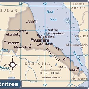
East African Rift tectonics, artwork

![]()
Wall Art and Photo Gifts from Science Photo Library
East African Rift tectonics, artwork
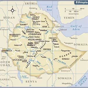
East African Rift tectonics. Block artwork of the Earths crust being pulled apart by plate tectonics in the Horn of Africa region of the East African Rift (Great Rift Valley). This system of faults and rifts runs for thousands of kilometres through eastern Africa from Ethiopia to Mozambique. It is caused by the divergence of the Nubian African (left) and Somali African (right) tectonic plates. The northern section is shown here. The Horn of Africa and Somalia are at right. The triangular depression at centre is the Afar Triangle in Ethiopia. Across top is the Red Sea (left) and the Gulf of Aden (right). At left is Sudan and the Blue and White branches of the Nile
Science Photo Library features Science and Medical images including photos and illustrations
Media ID 9221737
© CLAUS LUNAU/SCIENCE PHOTO LIBRARY
Afar Depression Africa Block Diagram Diagram Diverging Earth Science East Africa Ethiopia Ethiopian Fault Line Geological Red Sea Rift Rivers Seismic Seismology Tectonic Plate Afar Triangle Blue Nile Cutouts Diverge Divergence Djibouti Eritrea Faults Great Rift Valley Gulf Of Aden Rifts Somalia White Nile
EDITORS COMMENTS
This print titled "East African Rift tectonics" showcases a stunning artwork depicting the dynamic geological processes occurring in the Horn of Africa region. The image portrays the Earth's crust being pulled apart by powerful plate tectonics, revealing the intricate network of faults and rifts that stretch for thousands of kilometers through eastern Africa. The artwork vividly captures the divergence of two major tectonic plates: the Nubian African plate on the left and the Somali African plate on the right. The northern section is highlighted, with Ethiopia's Afar Triangle at its center, surrounded by Somalia and other neighboring countries. The mesmerizing composition also includes significant geographical features such as Sudan and branches of the Nile River - Blue and White Nile - depicted to the left. Alongside them lies a panoramic view of both Red Sea (left) and Gulf of Aden (right), emphasizing their role in this geological phenomenon. With its white background, this geologically accurate illustration serves as an invaluable resource for earth scientists, seismologists, or anyone interested in understanding these complex processes shaping our planet. Claus Lunau's masterful creation beautifully combines scientific accuracy with artistic flair to present a visually striking representation of East African Rift tectonics.
MADE IN THE USA
Safe Shipping with 30 Day Money Back Guarantee
FREE PERSONALISATION*
We are proud to offer a range of customisation features including Personalised Captions, Color Filters and Picture Zoom Tools
SECURE PAYMENTS
We happily accept a wide range of payment options so you can pay for the things you need in the way that is most convenient for you
* Options may vary by product and licensing agreement. Zoomed Pictures can be adjusted in the Cart.