Home > Historic > Ancient civilizations > Ancient Greece > Greek history
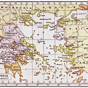
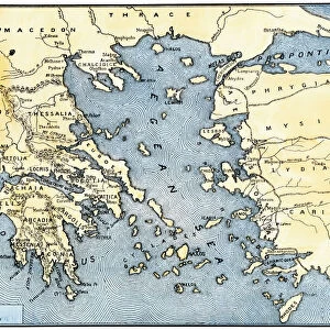
Map of Greek island of Corfu. Ionian Sea. Italian map. 1537

![]()
Wall Art and Photo Gifts from Mary Evans Picture Library
Map of Greek island of Corfu. Ionian Sea. Italian map. 1537
Mary Evans Picture Library makes available wonderful images created for people to enjoy over the centuries
Media ID 14337063
© Thaliastock / Mary Evans
1537 Cartography Corfu Ionian Mapping
FEATURES IN THESE COLLECTIONS
> Europe
> Greece
> Related Images
> Europe
> Italy
> Related Images
> Europe
> Related Images
> Historic
> Ancient civilizations
> Ancient Greece
> Greek history
> Maps and Charts
> Early Maps
EDITORS COMMENTS
This exquisite map print depicts the Greek island of Corfu, located in the Ionian Sea, as it appeared in the year 1537. The map, an Italian production of the 16th century, showcases the intricate details of the island's topography, with its winding coastline, intricate bays, and the walled city of Corfu, which is prominently featured in the center. The map also reveals the surrounding islands and the mainland of Greece, providing a glimpse into the geography of the region during the modern age. The map is a testament to the art of cartography during the 16th century, an age when exploration and discovery were driving forces in Europe. The intricate engraving and the meticulous attention to detail are evident in the various symbols used to denote different features, such as the representation of fortifications, towns, and bodies of water. The historical significance of this map lies in its ability to transport us back in time, allowing us to visualize the world as it was perceived over 480 years ago. It offers a unique perspective on the geography of the Mediterranean, providing valuable insights into the political and cultural landscape of the time. The map also highlights the rich history of Greece, a country that has played a pivotal role in shaping Western civilization. Corfu, in particular, has a storied past, having been ruled by various powers, including the Venetians, the French, and the British, before finally becoming part of Greece in 1864. In conclusion, this map print of Corfu and the Ionian Sea, produced in 1537, is a beautiful and intriguing piece of art and historical record. It offers a glimpse into the past, providing us with valuable insights into the geography, history, and culture of the region during the modern age.
MADE IN THE USA
Safe Shipping with 30 Day Money Back Guarantee
FREE PERSONALISATION*
We are proud to offer a range of customisation features including Personalised Captions, Color Filters and Picture Zoom Tools
SECURE PAYMENTS
We happily accept a wide range of payment options so you can pay for the things you need in the way that is most convenient for you
* Options may vary by product and licensing agreement. Zoomed Pictures can be adjusted in the Cart.