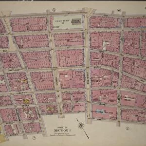
Plate 2, Part of Section 1: Bounded by Carlisle Street, Greenwich Street, Thames Street

![]()
Wall Art and Photo Gifts from Liszt Collection
Plate 2, Part of Section 1: Bounded by Carlisle Street, Greenwich Street, Thames Street
Plate 2, Part of Section 1: Bounded by Carlisle Street, Greenwich Street, Thames Street, Broadway, Pine Street, William Street, Exchange Place, Broad Street, Beaver Street, Bowling Green, Battery Place, and Hudson River Piers West Street
Liszt Collection of nineteenth-century engravings and images to browse and enjoy
Media ID 12672189
© Quint Lox Limited
Beaver Street Bounded By Broad Street Broadway Cartographic Exchange Place Greenwich Street Historic Map Part Of Section 1 Plate 2 Thames Street Vintage Map William Street Battery Place Bowling Green Carlisle Street Pine Street
EDITORS COMMENTS
This vintage map, titled "Plate 2, Part of Section 1: Bounded by Carlisle Street, Greenwich Street, Thames Street" takes us back in time to the bustling streets of old New York City. The intricate details and precise cartography allow us to explore the city as it once was. As we gaze upon this historic map, we can trace our fingers along Broadway and Pine Street, imagining the lively crowds that once filled these thoroughfares. We can envision the grandeur of Exchange Place and Broad Street, where commerce thrived amidst towering buildings. The map also reveals lesser-known corners of the city such as Carlisle Street and Beaver Street – hidden gems waiting to be discovered. It captures iconic landmarks like Bowling Green and Battery Place with remarkable accuracy. Transporting us further into history is the depiction of Hudson River Piers on West Street. These piers were vital hubs for trade and transportation during a time when ships lined its shores. With its faded colors and aged appearance, this print from Liszt Collection serves as a testament to New York's rich past. It allows us to appreciate how much has changed while reminding us that beneath modern skyscrapers lie layers upon layers of history. Whether you are an avid collector or simply captivated by nostalgia, this vintage map offers a glimpse into a vibrant era long gone but not forgotten.
MADE IN THE USA
Safe Shipping with 30 Day Money Back Guarantee
FREE PERSONALISATION*
We are proud to offer a range of customisation features including Personalised Captions, Color Filters and Picture Zoom Tools
SECURE PAYMENTS
We happily accept a wide range of payment options so you can pay for the things you need in the way that is most convenient for you
* Options may vary by product and licensing agreement. Zoomed Pictures can be adjusted in the Cart.