Home > Arts > Artists > I > Indian School Indian School
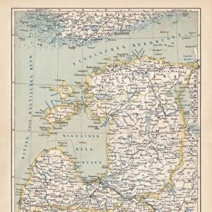
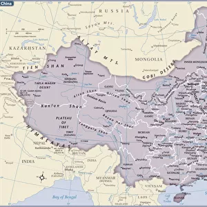
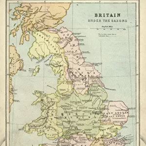
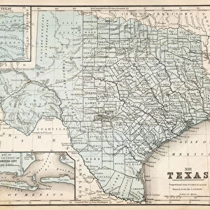
Map of Asia 1856

![]()
Wall Art and Photo Gifts from Fine Art Storehouse
Map of Asia 1856
Colton and Fitchs Modern School Geography by George W. Fitch - New York 1856
Unleash your creativity and transform your space into a visual masterpiece!
THEPALMER
Media ID 13668795
© Roberto A Sanchez
Backgrounds Grunge Grunge Image Technique India Indian Ocean Japan Paper Textured Effect Vignette China East Asia Obsolete
FEATURES IN THESE COLLECTIONS
> Arts
> Artists
> I
> Indian School Indian School
> Arts
> Artists
> J
> Japanese School Japanese School
> Arts
> Artists
> O
> Oceanic Oceanic
> Arts
> Modern art pieces
> Textures and patterns in modern
> Modern paintings
> Arts
> Modern art pieces
> Textures and patterns in modern
> Asia
> India
> Related Images
> Fine Art Storehouse
> The Magical World of Illustration
> Palmer Illustrated Collection
> Fine Art Storehouse
> Map
> Historical Maps
EDITORS COMMENTS
This print showcases a vintage map of Asia from the year 1856, taken from George W. Fitch's renowned "Colton and Fitchs Modern School Geography" in New York. The intricate details and exquisite craftsmanship of this engraved image transport us back to a time when cartography was an art form in itself. The map depicts the vast continent of Asia with its diverse countries and regions, including Japan, India, China, and East Asia. The Indian Ocean stretches out majestically in the background, emphasizing the importance of maritime trade routes during that era. The textured effect on the paper adds a touch of nostalgia to this piece, reminding us of its age and historical significance. The grunge image technique further enhances its antique charm by giving it an aged appearance. As we gaze upon this remarkable illustration, we can't help but marvel at how much our world has changed since 1856. This obsolete representation serves as a reminder of how far we have come in terms of physical geography and technological advancements. "The Map of Asia 1856" by THEPALMER is not just a mere print; it is a portal into history—a tangible connection to our past. Whether displayed in homes or offices, it sparks curiosity and invites contemplation about the rich tapestry that makes up our world today.
MADE IN THE USA
Safe Shipping with 30 Day Money Back Guarantee
FREE PERSONALISATION*
We are proud to offer a range of customisation features including Personalised Captions, Color Filters and Picture Zoom Tools
SECURE PAYMENTS
We happily accept a wide range of payment options so you can pay for the things you need in the way that is most convenient for you
* Options may vary by product and licensing agreement. Zoomed Pictures can be adjusted in the Cart.