Home > Europe > France > Maps
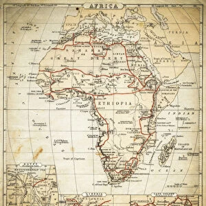
Map of Africa after the signing of the Anglo-French Agreement of March 1899 (colour litho

![]()
Wall Art and Photo Gifts from Fine Art Finder
Map of Africa after the signing of the Anglo-French Agreement of March 1899 (colour litho
XEE4162122 Map of Africa after the signing of the Anglo-French Agreement of March 1899 (colour litho) Illustration for Le Petit Journal, 9 April 1899 (engraving) by French School, (19th century); Private Collection; Stefano Bianchetti; French, out of copyright
Media ID 23311798
© Stefano Bianchetti / Bridgeman Images
International Relations Geographical Map
FEATURES IN THESE COLLECTIONS
> Africa
> Related Images
> Fine Art Finder
> Artists
> French School
> Fine Art Finder
> Artists
> Gustave Dore
> Maps and Charts
> Related Images
EDITORS COMMENTS
This print showcases the "Map of Africa after the signing of the Anglo-French Agreement of March 1899". The vibrant colours and intricate details bring to life this historical moment captured by French School in the 19th century. Published as an illustration for Le Petit Journal on April 9,1899, this engraving offers a glimpse into the complex web of international relations and colonialism that defined Africa during this era. The map highlights the territorial divisions resulting from the agreement between Britain and France, two major powers vying for control over African territories. It serves as a visual representation of their respective spheres of influence, showcasing how borders were redrawn and new boundaries established. This artwork not only provides valuable geographical information but also sheds light on significant historical events. It symbolizes an era when European powers sought to expand their empires through colonization, often at great cost to indigenous populations. The map invites viewers to contemplate the impact of these actions on African nations and peoples. As we observe this masterpiece by Stefano Bianchetti, we are reminded that art has always played a crucial role in documenting history. Through its vivid depiction, it encourages us to reflect upon our past while considering its implications for our present and future.
MADE IN THE USA
Safe Shipping with 30 Day Money Back Guarantee
FREE PERSONALISATION*
We are proud to offer a range of customisation features including Personalised Captions, Color Filters and Picture Zoom Tools
SECURE PAYMENTS
We happily accept a wide range of payment options so you can pay for the things you need in the way that is most convenient for you
* Options may vary by product and licensing agreement. Zoomed Pictures can be adjusted in the Cart.