Home > Europe > France > Canton > Herault
L Herault (34), Languedoc Roussillon (Languedoc-Roussillon) - France and its Colonies. Atlas illustrates one hundred and five maps drawn from the maps of the depot of war, bridges and footwear and the Navy by M. VUILLEMIN. 1876
, Languedoc Roussillon (Languedoc-Roussillon) - France and its Colonies. Atlas illustrates one hundred and five maps drawn from the maps of the depot of war, bridges and footwear and the Navy by M. VUILLEMIN. 1876")
![]()
Wall Art and Photo Gifts from Fine Art Finder
L Herault (34), Languedoc Roussillon (Languedoc-Roussillon) - France and its Colonies. Atlas illustrates one hundred and five maps drawn from the maps of the depot of war, bridges and footwear and the Navy by M. VUILLEMIN. 1876
XEE4144564 L Herault (34), Languedoc Roussillon (Languedoc-Roussillon) - France and its Colonies. Atlas illustrates one hundred and five maps drawn from the maps of the depot of war, bridges and footwear and the Navy by M. VUILLEMIN. 1876. Private collection. by Vuillemin, Alexandre (1812-1886); Private Collection; (add.info.: L Herault (34), Languedoc Roussillon (Languedoc-Roussillon) - France and its Colonies. Atlas illustrates one hundred and five maps drawn from the maps of the depot of war, bridges and footwear and the Navy by M. VUILLEMIN. 1876. Private collection.); Stefano Bianchetti; French, out of copyright
Media ID 25153706
© Stefano Bianchetti / Bridgeman Images
Atlas Book H And Xe9 Herault 34 Languedoc Roussillon Rault 34 Geographical Map
FEATURES IN THESE COLLECTIONS
> Europe
> France
> Canton
> Herault
> Fine Art Finder
> Artists
> Alexandre Vuillemin
> Maps and Charts
> Related Images
> Services
> Royal Navy
EDITORS COMMENTS
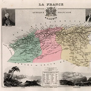
This print showcases a historical atlas titled "L Herault (34), Languedoc Roussillon (Languedoc-Roussillon) - France and its Colonies". Published in 1876, the atlas features an impressive collection of one hundred and five maps meticulously drawn by M. VUILLEMIN. These maps were sourced from various esteemed institutions such as the depot of war, bridges and footwear, and the Navy. The image captures a glimpse of this remarkable atlas that is now part of a private collection. The intricate engravings on each page depict geographical details, providing valuable insights into the region's topography during that era. Alexandre Vuillemin, renowned for his cartographic expertise, skillfully crafted these maps with precision and accuracy. The vibrant colors used in this particular map add depth to its visual appeal. It specifically focuses on L Herault (34), situated within the picturesque region of Languedoc Roussillon in southern France. This area was known for its rich history and cultural heritage. Stefano Bianchetti beautifully captured this engraving through his lens, preserving it for generations to come. As we admire this photograph print today, we are transported back in time to witness the mastery behind Vuillemin's work while gaining a deeper understanding of France's colonial territories.
MADE IN THE USA
Safe Shipping with 30 Day Money Back Guarantee
FREE PERSONALISATION*
We are proud to offer a range of customisation features including Personalised Captions, Color Filters and Picture Zoom Tools
SECURE PAYMENTS
We happily accept a wide range of payment options so you can pay for the things you need in the way that is most convenient for you
* Options may vary by product and licensing agreement. Zoomed Pictures can be adjusted in the Cart.