Home > Historic > Colonial America illustrations > American colonies
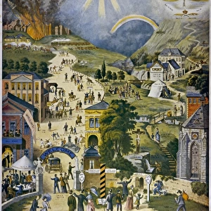
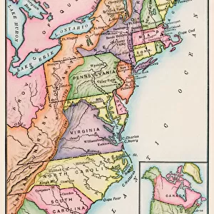
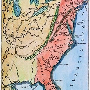
Thirteen original colonies in 1776

Wall Art and Photo Gifts from North Wind
Thirteen original colonies in 1776
American colonies at the outbreak of the Revolution.
Printed color lithograph of a 19th-century illustration
North Wind Picture Archives brings history to life with stock images and hand-colored illustrations
Media ID 5881847
© North Wind Picture Archives
13 Colonies 1700s 1776 18th Century American Revolution Atlantic Coast Canada Colonial Colony Quebec Revolution Revolutionary War States 1769 Colonies Thirteen Colonies
FEATURES IN THESE COLLECTIONS
> Historic
> Colonial America illustrations
> 18th century America
> Historic
> Colonial America illustrations
> American colonies
> Historic
> Colonial America illustrations
> Colonial America
> Historic
> Colonial America illustrations
> Historic
> Colonial history
> Colonial art and artists
> Maps and Charts
> Popular Maps
> Maps and Charts
> Related Images
> North America
> Canada
> Maps
> North America
> Canada
> Related Images
> North Wind Picture Archives
> American Revolution
> North Wind Picture Archives
> Maps
> Popular Themes
> Maps and Charts
EDITORS COMMENTS
This 19th-century color lithograph transports us back in time to the American colonies at the onset of the Revolution in 1776. The illustration showcases the thirteen original colonies, each represented by its unique emblem, nestled along the Atlantic Coast from present-day Maine to Georgia. The map highlights the rich heritage and traditional boundaries of these colonies, including Quebec, which was then under French rule. The year 1776 holds significant historical importance as it marks the signing of the Declaration of Independence, which officially declared the thirteen American colonies as independent states. However, it is essential to note that the Revolution had already begun in 1765 with the passage of the Stamp Act, which led to widespread protests and the formation of the Sons of Liberty. The Proclamation of 1769, also known as the Quebec Act, played a crucial role in the tensions between the colonies and Great Britain. This act extended the northern boundary of Quebec to the Ohio River, effectively denying American settlers access to the land. This decision further fueled the growing resentment towards British rule and contributed to the escalating conflict. This vintage illustration serves as a testament to the complex history of North America during the 1700s. The thirteen colonies, which later became the thirteen states, stood united in their quest for independence, paving the way for the United States of America. The intricate details and vibrant colors of this 18th-century map bring the history of this pivotal period to life, making it a must-have for history enthusiasts and art collectors alike.
MADE IN THE USA
Safe Shipping with 30 Day Money Back Guarantee
FREE PERSONALISATION*
We are proud to offer a range of customisation features including Personalised Captions, Color Filters and Picture Zoom Tools
SECURE PAYMENTS
We happily accept a wide range of payment options so you can pay for the things you need in the way that is most convenient for you
* Options may vary by product and licensing agreement. Zoomed Pictures can be adjusted in the Cart.