Home > Europe > France > Caen
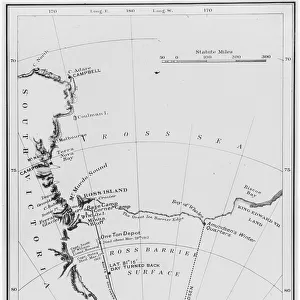
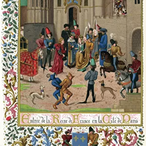
A map showing the movement of King Edward III through France from Barfleur to Calais in

![]()
Wall Art and Photo Gifts from Mary Evans Picture Library
A map showing the movement of King Edward III through France from Barfleur to Calais in
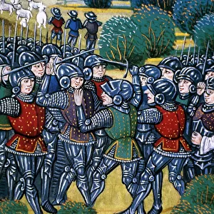
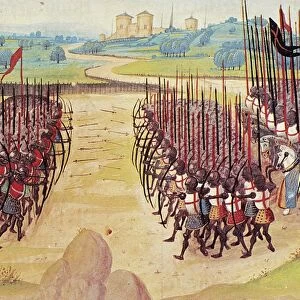
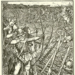
A map showing the movement of King Edward III through France from Barfleur to Calais in the early 14th century, marking the battles at Crecy and Caen. Date: 1346
Mary Evans Picture Library makes available wonderful images created for people to enjoy over the centuries
Media ID 20951853
© Mary Evans Picture Library
1346 Battles Caen Calais Crecy Marking Movement Years 14th Barfleur
FEATURES IN THESE COLLECTIONS
> Historic
> Battles
> Related Images
> Maps and Charts
> Early Maps
> Maps and Charts
> Related Images
> Mary Evans Prints Online
> New Images May
EDITORS COMMENTS
This intricately detailed map provides a visual representation of King Edward III of England's military campaign through France during the pivotal year of 1346. The map marks the significant movements of the English army from their initial landing at Barfleur, in Normandy, to their eventual victory and retreat at Calais. The early 14th century was a tumultuous time in European history, with the Hundred Years War between England and France reaching a critical point. King Edward III, determined to assert English claims to the French throne, led a formidable army across the English Channel. The map illustrates the strategic locations of key battles, most notably the decisive Battle of Crecy, which took place on August 26, 1346, and the Battle of Caen, fought on August 28, 1346. The Battle of Crecy is considered a turning point in the Hundred Years War, as the English longbowmen inflicted a devastating defeat upon the French knights. The map shows the approximate locations of the English and French forces, as well as the surrounding terrain. The Battle of Caen, though less well-known, was significant as it marked the capture of the city by the English and the beginning of their siege of Calais, which would last for over a century. This map offers a unique perspective on the military strategies and tactics employed during the Hundred Years War, providing valuable insight into the complex political and military landscape of the early 14th century. The intricate details and accurate depictions make it an essential resource for historians, students, and anyone interested in the history of this period.
MADE IN THE USA
Safe Shipping with 30 Day Money Back Guarantee
FREE PERSONALISATION*
We are proud to offer a range of customisation features including Personalised Captions, Color Filters and Picture Zoom Tools
SECURE PAYMENTS
We happily accept a wide range of payment options so you can pay for the things you need in the way that is most convenient for you
* Options may vary by product and licensing agreement. Zoomed Pictures can be adjusted in the Cart.